Spatial data and its types
Spatial data
Spatial data have two main components that set them apart from regular data, making them suitable for mapping:
- "Where": Referring to the location of the data
- "What": Referring to the information about the data
Types of spatial data
Spatial data can be categorized into two types: raster and vector.
Raster data
Raster data can be described as a grid of cells (rows and columns), similar to pixels in pictures.
- Each cell contains a value representing a specific characteristic of a studied geography
- Commonly used for continuous data, like land use, temperature or elevation (e.g., Digital Elevation Models or DEMs, which consist of elevation values)
- Raster data are stored as a grid of cells, with each cell having a unique value based on its x, y, and z coordinates within the grid
- Can be either continuous (progressive, varying data) or discrete (thematic or categorical)
- Rectangular tessellated rasters are most commonly used due to their mathematical simplicity
- Examples of raster data include satellite images or aerial photos
- Most commonly seen in the GeoTIFF file format
Vector data
Vector data are represented as points, lines, and polygons.
- Commonly used for representing discrete or categorical data, such as political boundaries, roads, or land cover
- Stored as sets of x, y coordinate pairs defining point locations, or as series of coordinates defining vertices of lines or polygons
- Can be categorized into 0-dimensional, 1-dimensional, and 2-dimensional forms (geometric primitives). In the 0th dimension, coordinate points exist independently. In the 1st dimension, two points can form a line. In the 2nd dimension, three or more lines can be joined to create a polygon
- Vector data allows for more efficient storage and manipulation
- Can convert vectors to raster and vice versa using specialized software (e.g., ArcGIS Pro, and QGIS)
- Common data formats include CSV, KML (Google), GeoJSON, and Shapefile (Esri)
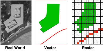
Comparing real world data to types of spatial data
Credit: CUNY Department of Geography and Environmental ScienceBasemaps and data
Basemaps are fundamental background layers in mapping, providing critical geographical context for all overlaid data. Basemaps can be raster or vector. Examples of raster basemaps include OpenStreetMap and OpenTopoMap, which provide pre-rendered map tiles in PNG format.
Overlaying vector data, such as polygon features from a GeoJSON layer, onto a raster basemap is common to visualize specific geographic information within the broader context provided by the underlying imagery.
Similarly, raster data, such as additional imagery layers, can be superimposed over a raster basemap. While vector basemaps offer performance and customization advantages, the basemap examples provided below are raster-based.
Check out the examples below:
This map shows U.S. states as colored polygons on top of a street/navigation basemap. You can cycle through different themes using a dropdown menu. The legend classifies what the colors represent for each theme.
This map's raster basemap shows terrain/topography, and the map has an image SVG graphic on top.
Test your knowledge
Which is preferred for representing continuous data such as elevation? (Hint: you want the data with the more detailed representation of terrain)