Visual encoding
By Omar Kawach
Marks
Cartography is considered a graphical form of communication. Communicating with maps would not be possible without the main building blocks for the visual encoding of vector data. The main building blocks for visual encoding are marks and channels. Marks are a set of geometric primitives made up of:
- Points
- Represent locational information
- A single point with X, Y coordinates (Cartesian coordinate system)
- A single point with latitude, longitude coordinates (geographic coordinate system)
- A single point with an address
- E.g., Houses, hospitals, restaurants, etc.
- Represent locational information
- Lines
- Represent a connection with measurable length
- Two vertices can be connected by a line to form a route
- E.g., Highways, trails, bus routes, etc.
- Represent a connection with measurable length
- Areas
- Represent a boundary with measurable area
- Three vertices can be closed with two lines to form a boundary
- E.g., Municipal boundaries, lakes, parks, etc.
- Represent a boundary with measurable area
Channels
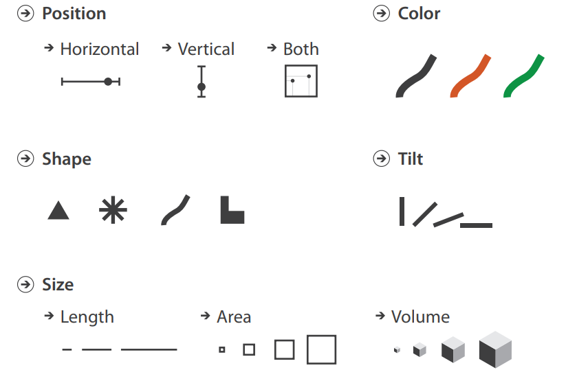
The appearance of marks can be manipulated using channels:
- Position
- Change in X and/or Y position
- Color
- Color hue
- Primary and secondary colors
- Color luminance (or brightness)
- The lightness or darkness of a color
- Color saturation
- How vivid or washed-out a color appears
- Color hue
- Shape
- Change in shape, which there are an infinite number of
- Glyphs are considered a part of this channel
- E.g., Egyptian hieroglyphs, and other typographic characters or symbols.
- Tilt
- Change in Angle and/or Alignment
- Size
- Change in Length, Area, and/or Volume
Visually encoded map
Now that you've learned about visual encoding, play around with the map below to see which marks and channels are displayed, as well as the data they contain. You can alter the style of the points by pressing the bottom-right button.
Test your knowledge
0 of 5 correct
When you hovered over a hospital, was the location information represented as an address or latitude, longitude coordinate?

