Projections
By Omar Kawach
Projection types
When it comes to presenting maps to readers, geographers must choose a projection that is appropriate for the map's purpose and location. Projections transform three-dimensional curved surfaces to two-dimensional flat surfaces. Consequently, such transformations cause distortion to the maps. The following are the 4 types in which the relationship between features on a map may be distorted or preserved:
- Distance (Equidistant)
- Preserves distance between features
- True Direction (Azimuth)
- Preserves direction between features
- Measured in degrees (°)
- Shape / Angle (Conformal)
- Cannot preserve shape and area at the same time
- Continents distorted
- Area (Equal-Area)
- Distorts distance and shape
- Preserves features to their exact size
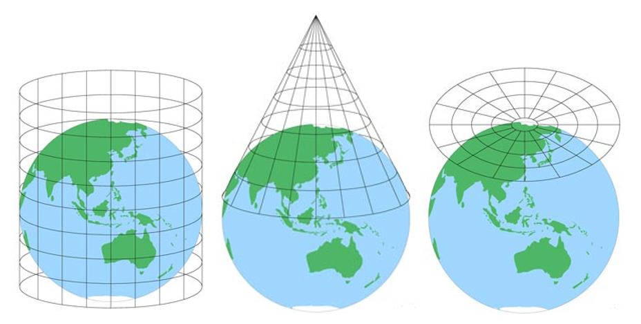
Projection techniques
The projection techniques, which affect the longitude (vertical lines) and latitude (horizontal lines) on a map, are another significant factor to consider. The following are the 3 primary projection techniques:
- Cylindrical
- Longitude lines appear straight, equally spaced, and parallel
- Latitude lines appear straight, and sometimes not consistently equally spaced
- Conical
- Longitude lines appear as diverging
- Latitude lines appear circular around the poles
- Azimuthal (or Planar)
- Increasingly distorted from the centre point (typically the South or North Pole as the centre point)
- Longitude lines appear equally spaced and straight which become increasingly radiant
- Latitude lines appear as equally spaced centric circles
Projection explorer
Try out the projection explorer below now that you've learned about projection types and techniques.
Test your knowledge
The Albers projection uses which technique and type?