Spatial data and its types
By Omar Kawach
Spatial data
Spatial data have two main components that set them apart from regular data, making them suitable for mapping:
- "Where": Referring to the location of the data
- "What": Referring to the information about the data
Types of spatial data
Spatial data can be categorized into two types: raster and vector.
Raster data are described as a grid of cells (rows and columns), similar to pixels in pictures.
- Each cell contains a value representing a specific characteristic of a studied geography
- Commonly used for continuous data, like land use, temperature or elevation (e.g., Digital Elevation Models or DEMs, which consist of elevation values)
- Raster data are stored as a grid of cells, with each cell having a unique value based on its x, y, and z coordinates within the grid
- Can be either continuous (progressive, varying data) or discrete (thematic or categorical)
- Rectangular tessellated rasters are most commonly used due to their mathematical simplicity
- Examples of raster data include satellite images or aerial photos
- Most commonly seen in the GeoTIFF file format
Vector data are represented as points, lines, and polygons.
- Commonly used for representing discrete or categorical data, such as political boundaries, roads, or land cover
- Stored as sets of x, y coordinate pairs defining point locations, or as series of coordinates defining vertices of lines or polygons
- Can be categorized into 0-dimensional, 1-dimensional, and 2-dimensional forms (geometric primitives). In the 0th dimension, coordinate points exist independently. In the 1st dimension, two points can form a line. In the 2nd dimension, three or more lines can be joined to create a polygon
- Vector data allows for more efficient storage and manipulation
- Can convert vectors to raster and vice versa using specialized software (e.g., ArcGIS Pro, and QGIS)
- Common data formats include CSV, KML (Google), GeoJSON, and Shapefile (Esri)

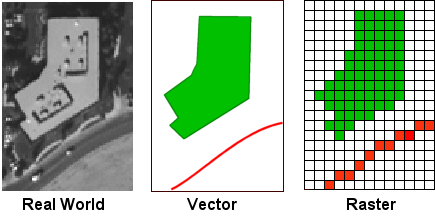
Comparing real world data to types of spatial data
Credit: CUNY Department of Geography and Environmental ScienceCompare vector and raster data
Interaction coming soon
Compare elevation maps
Interaction coming soon
Test your knowledge
0 of 3 correct
Which is preferred for representing continuous data such as elevation? (Hint: you want the data with the more detailed representation of terrain)